Coordinates from dGPS Not Accurate

I confess I haven’t been following this thread very closely. So I only just realized you’re making an autopilot for the NXT. Sounds like a fun personal project - I imagine others will be interested as well (e.g. on sites like Hack-a-Day).

I’m a little familiar with ArduPilot - I have a larger robot that I want to use Ardupilot with along with ROS. This led me to the GoPiGo3 as an easier initial learning platform for ROS navigation.

Best of luck with your project - I’m not at the GPS stage. When I am I’m sure I’ll be back to re-read these posts.
/K

1 Like

If they’re using moonshine, depends on the distillation skills of the moonshiner. Never buy from a moonshiner who doesn’t drink their own product :slight_smile:
/K

1 Like

True.

My family comes from a long line of moonshiners in the mountains of Virginia, West Virginia, Kentucky and North Carolina. Where they come from, if moonshine is suspected of being tainted, the locals force the 'shiner to drink his own 'shine to prove it’s OK.

In the commercial sense, there’s moonshine and there’s moonshine.

  • “Commercial” moonshine is a nom de plume for high-strength alcohol and is pure advertising.
  • “Real” moonshine - (samagon - самогон) - is held to high standards by the community it serves. Russians have a very low tolerance for bad booze.
     

“Moonshine” isn’t that uncommon. In the same way that there’s a thriving “home brew” industry in the US - and you can almost buy beer-making kits from WalMart, commercially available and certified stills are available from many sources in Russia and moonshining is an active hobby here.

1 Like

Although I grew up in Arkansas, it wasn’t in the Ozarks, which is where I think of traditional moonshine being distilled, so I didn’t have any personal contact.

My wife is from Ireland, and in college tended bar at a small hotel in west Cork during the summers. There she did make the acquaintance of makers of traditional Irish poitín, or at least friends thereof. When we got married in her hometown in Tipperary, she wanted to have a traditional Irish wedding cake, which is more of a fruitcake than a US wedding cake. And traditionally it’s liberally loaded with poitín. She let her friends know she needed some of the traditional ingredients, and a few days before the wedding a couple of unlabeled glass bottles showed up as an early wedding gift. I was a bit wary of the stuff, but was assured that it was perfectly fine (which it proved to be).

And you’re right - many of the craft distillers in Arkansas make a “Moonshine” now, which I think is essentially their bourbon base that’s higher ABV, and not aged (so no color from the barrels).

I’d still be wary of hobby moonshine unless I knew the person really well. I have a degree in chemistry and have done different kinds of distillation, so I’m well aware that it only takes a little lack of attention on one distillation to make for a very bad product.

/K

1 Like

Ooh! Cool beanies!

I’ve done fractional distillation myself and it’s not a simple task so I know you’re right.

I can’t speak with any confidence but - if I remember rightly - tainted moonshine comes from people who are careless and either don’t keep their still clean and bright inside, or use unsuitable metals - which are considerably less expensive than pure copper sheets and copper rivets.

As far as moonshining goes, there’s a story that circulated in my family about how relatives “gamed” the system during Prohibition.

Background:
Apparently, (as you know), even the best and most well-built still has a limited lifetime, after which it’s usually destroyed so that unscrupulous moonshiners can’t try to repair and re-use it. This would ultimately lead to tainted 'shine and a stain on the entire industry so worn-out stills were deliberately destroyed.

The Story:

It appears that a fairly large number of my relatives from back then were “master moonshiners” and had a large and loyal following for their high quality 'shine.

Other parts of the family had been recruited by the ATF and FBI to help stamp out moonshining in that region. Part of the incentive was a cash bounty for every still they found and destroyed, something like $100 in gold which was huge money in the 1930’s.

To claim the bounty, they had to return with parts of the still, including the “worm” which was the tube used to cool and liquefy the distilled vapors.

Apparently what happened was that the moonshiners would let the “other side of the family” know when a still was going to be taken out of service because it was worn out. The “government” side of the family would then “find” the still, “destroy” it, grab the parts needed, and go claim their bounty.

They would then use the government’s cash to finance the moonshiners by buying the moonshine they were supposed to be eliminating.

This racket went on until WWII if I remember rightly.

What a group!

2 Likes

Really great story. People always figure out a way to work the system.

If I recall it was the use of lead that caused some of the problems of contaminated moonshine (hence favoring copper parts). Methanol has a lower boiling temperature than ethanol, so comes off first. So you have to pay attention to the temperatures to know when you can stop throwing away the distillate and start keeping it from what I recall.
/K

1 Like

I am really getting an education, and not just about GPS, but about alcohol as well. And to think I had been holding off all these years out of concern for my eyesight. :grinning:

Anyway, Hi KeithW. Yes, I am attempting to build an NXT-powered autopilot. As you probably saw in the posts, it’s not an original idea on my part; rather, I hope to recreate what someone else did some time ago. An internet search will turn up a few other NXT autopilot projects, but none made it to the flying stage, other than Chris Anderson’s effort, that I can find. I will come back and post whatever progress I make.

My confidence with the dGPS is growing since I think I have a way to work around what appears to be an initialization issue. It’s a shame that none of the Dexter Industries folks, who might have had some insight into this, are still around. As Jim suggested, maybe this is one reason why the sensor is no longer offered. I actually came across an old link where they were being sold in clearance at $20 per unit. I’m a little surprised that no GPS unit is available for Lego NXT or EV3, but maybe all of the other platforms, e.g. Arduino, Raspberry Pi, etc., have taken over this field.

Thanks,
Paul

1 Like

My understanding of the process was that, (of course), they didn’t have the equipment or chemicals to do a qualitative analysis, but an experienced moonshiner could tell when the starting condensate started evolving ethanol.

The nose and tongue are sensitive qualitative instruments so they would use both smell and taste, (putting a small drop on the tongue), to determine when they should start bottling the result of the distillation.

In fact, distillation of moonshine is a careful two-step process.
One step to drive off the mixed chemicals from the original mash, and a second, more careful, distillation to drive off any higher hydrocarbons and any methanol that might have been produced.

The first part of the second distillation was usually thrown away until the moonshiner knew he had ethanol, then he put it in a jug. After the ethanol was driven off, the last part of the condensate, called “backings”, was accumulated - at least in part - and was used to dilute the high-strength ethanol to “commercial” strength without watering it down and affecting the taste.

An experienced moonshiner was, in essence, a competent chemist.

Very interesting.

They had to be - social Darwinism at its best. The incompetent moonshiners died blind with no kidney function.
/K

1 Like

So, I have done more experimenting with the dGPS sensor. One of my immediate goals was to recreate the Dexter Industries SARG project (Simple Autonomous Robot GPS). It took a lot of testing and experimenting to finally get the bot to be guided by GPS and compass sensors. The main problem continues to be the inability of the dGPS sensor to get a good location reading on startup. After a great deal of frustration with that, I finally fell back on what Dexter Industries did themselves. They simply carried the bot to where they wanted a waypoint to be and used whatever coordinates the dGPS gave, regardless of where they might be in the real world. This is fine for close waypoints, but not at all workable if you need to set your waypoints from a map over much larger distances, i.e. as with a model airplane. I also discovered that the confines of my test area, my driveway, seem to be simply too small to get reliable distance measurements out of the dGPS, so instead of using proximity to a waypoint to change a waypoint or stop the bot, I used travel time toward the waypoint. It’s a bit of a cheat, but it’s the only way I could get this to work. Also, I set those waypoints far away, i.e. way out in my yard. Finally, the bot does not travel far enough and soon enough to get reliable heading and/or angle of travel information out of the dGPS, so the compass is required for current heading data.

The video is not great, but the first waypoint the bot travels toward is at the lower end of my driveway. After travelling for 15 seconds in that direction, the waypoint changes to one off the back corner of my house. As the bot goes in that direction you’ll see a little dog-leg. I think my house momentarily blocks the compass or GPS readings, but the bot recovers. It stops after 15 seconds of travel toward the second waypoint.

What I am learning is that GPS seems to be much more reliable when it’s on the move and traveling over much larger distances. Ironically, I think I’ll get better performance out of the dGPS when, and if, I get it in the air, than when it’s on the ground.

Video: GPS-Bot

One last thing–The bot does not perform well when the travel direction is within a few degrees of north. Directional control is based on heading toward the current waypoint minus current heading. The dGPS provides the former direction and the compass provides the latter direction. The problem, I think, has to do with magnetic heading (compass) vs. true heading (dGPS). To convert the compass heading to true I have to subtract 12 degrees from the compass reading. This can lead to negative degrees, so I wrote a small routine to deal with that, i.e. add 360° to any corrected compass readings from -1° to -12°. I don’t know why yet, but the bot simply goes in circles when it tries to go in that range of direction. Once again, this will be easier to deal with in the air. A model plane will travel far enough and fast enough to use the dGPS for current heading and/or angle of travel data. The compass will actually not be necessary.

Thanks,
Paul

2 Likes

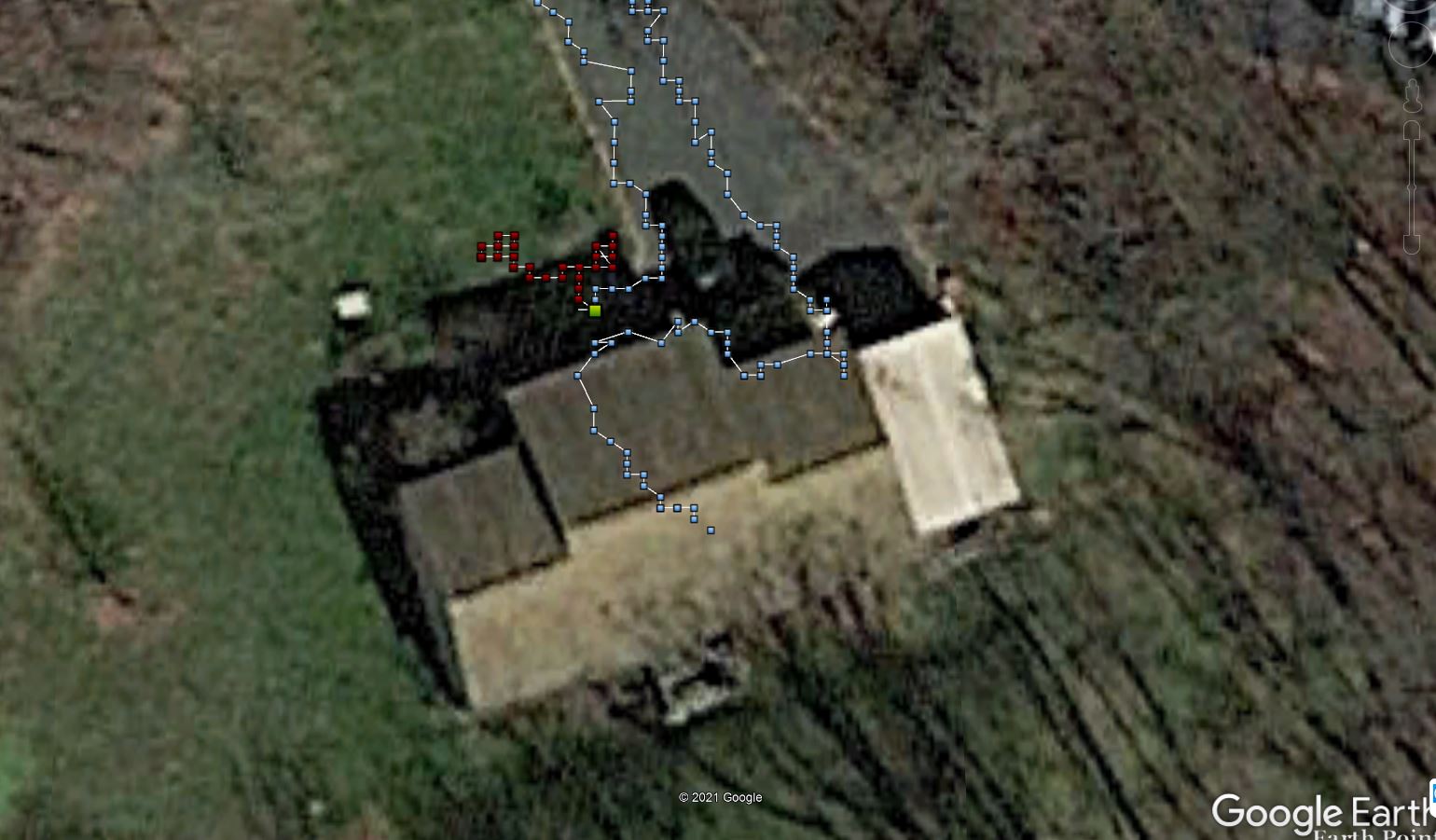
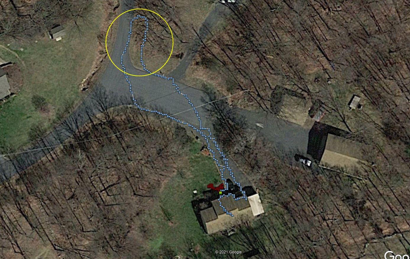
You are actually confirming what others have also noticed with a GPS.

My Garmin GPS can’t reliably travel between the beginning and end of my driveway either.

There are “precision” GPS devices but I suspect that they cost like fully tricked-out Bugatti.

I suspect that their “motion” algorithm is more complex than simple “here” and “there” coordinate pairs.

I suspect that they use direction-of-travel, velocity-of-travel, and accurate time to fine-tune the GPS position. Note that, depending on the resolution of the TOD returned by the GPS receiver, you might well have the equivalent of a Cesium Stratum-0, Atomic time-source with you. :wink: GPS time has to be insanely accurate to even give you an approximate location.

Viz.:
I am moving in direction “X”, at velocity “V”, for a period of time “T”. Therefore if I assume I started here (coordinates at lat, lon), and I traveled in “X” direction for “T” time at “V” velocity, I should now be here (lat’, lon’).

You have done more research with the GPS in the last week or so than I have done in my entire life! (laughing).

One thought.

Have you tried to select a target location further away - like fractions of a mile - and take the GPS on a bicycle or in a car?

Another thought:
I notice that my Garmin, when moved to a entirely new location requiring a new satellite map, (i.e. From the US to Europe, or a large distance across the US), the original fixes tend to wander and even after attaining “high” precision, it often thinks I am doing one thing when I am doing something else. It’s only after being alive, attaining a high-precision fix, and maintaining that fix for a long period of time, (> 30 min to possibly hours), that the perceived accuracy settles down and does what it is supposed to.

Possibly the “I’m here” algorithms need a certain amount of accumulated data to average out all the potential errors? I don’t know.

Also remember that automotive GPS’s assume you are on a road and “snap” to the nearest one.

I also suspect that the need for higher accuracy, faster acquire times, and better precision is part of the reason that aviation and instrumentation class GPS devices are hideously expensive compared to “automotive” class devices.

1 Like

Hi Jim,

I did try logging some data on a drive with the dGPS, but it didn’t work out at the time. I might not have had it in a spot to get good satellite coverage. In any case, I know a lot more know and will do that again.

I’m going to keep my eyes open for a dGPS that might come up on ebay or Amazon. I do think there might be something amiss with my particular unit. The fact that I can’t find anything on the internet of a similar experience with this unit leads me to think in that direction.

The GPS sensor that I have for the ArduPilot I mentioned had nothing close to these kinds of issues. I would fire it up at the flying field and later, when I’d plot the data in Google Earth, it was spot on, and I mean within a few feet. Your comment about pinouts reminded me that I already have another GPS sensor, but even if the pinouts match, I don’t think it would interact with the dGPS blocks used in NXT-G. If I were working in code, that might not be an issue.

Thanks,
Paul

2 Likes

I forget, but I don’t think my memory is as good as it used to be. Therefore, I dug out my old ArduPilot and its GPS sensor to see if its performance was as good as I recall relative to the dGPS.

In the image zoomed-in close to my house, the red dots show the ArduPilot/GPS as it was staring up and finding itself. The red dots represent a time span of a few minutes. The larger yellowish-green dot is where the unit was during start-up. I had it on a fence post just outside our front porch. That dot is well within a 24" radius of the actual location, maybe even closer. I took the unit for a walk. The left path markers are within about 36" of where I actually was. The big exception is the area circled in yellow. That loop, or series of dots, is 10-15’ off of the actual place I walked. However, outside of that yellow circle, the path is back to being within 36" of where I walked. It follows me up the center of our driveway, to the side of the house were I was for a moment, and then up our front walk and even into the house where I shut things down.

This is why I never quite understood the specs that say a GPS is within a 30 foot radius. My experience with the ArduPilot system is much, much, better than that. Unlike the dGPS, I get excellent initialization results, i.e. the unit immediately knows where it is on startup, every time.

Given the good results at the start and end of my walk, I can’t explain the error in the loop area. I was gathering this data via telemetry and my laptop was on the porch as I walked. Maybe when I got to the road where the loop is, the telemetry was off. I kind of doubt that, but who knows.

Paul

1 Like

Damn!

Maybe you’re right? If I weren’t hell-and-gone all the way in Moscow Russia, I’d arrange a swap for my dGPS unit which is useless as Teats on a Boar Hog, (at least to me, by the way).

I could mail it from here but, (assuming it actually got out of Russia without it being pinched), it would be a month or so before you received it.

Dawggonit! I sure wish I could help. . . .

Maybe after I get some tax work done, I can try jury-rigging up something and hook it up to my GoPiGo. I’d have to find a i2c level-shifter though since the dGPS is 5v logic and the Raspberry Pi is 3v logic.

Drat!

Hi Jim,

Yeah, it would be nice to compare my dGPS results against another dGPS. If one does show up on ebay, I’ll try to snatch it up.

Thanks,
Paul

1 Like

By the way, I found an earlier post of mine that had a pinout that referenced signals by name - just in case anyone has an idea that they’d like to tie this up to an i2c buss - just be warned, this is a 5v device and will need level-shifting to work with a Raspberry Pi.

I don’t know what the “ANA” signal is though - it appears to be a “n/c” (not connected) pin.

And while we’re on the subject of direction-finding:

https://maps.ngdc.noaa.gov/viewers/historical_declination/

This NOAA site allows you to look as isogonic lines as they’ve moved (in our neck of the woods) from east to west over the years. Interesting!

In fact, in 1981 an isogonic line bisected Worcester MA. where I live (when I’m actually IN the US for a change!)

Well, the verdict is in and my dGPS is kaput. On a whim, I contacted Modular Robotics (a.k.a. Dexter Industries) and asked if there was any chance at all that they still had a dGPS lying around that I could buy. It turns out they did. I bought it, it arrived and I tested it. The results are like night and day. On start up, it consistently finds itself within a few feet of where it actually is in the real world. In the attached image, red indicates a path I walked while yellow indicates dGPS logged data points. For some reason, that area to the northeast gives odd results, as I saw with my test of another GPS device posted above. In any case, these are great results. I’m anxious to rerun the SARG test and see if my dGPS guided ground vehicle performs better.

Thanks,
Paul

P.S. – As I look at the image closer, I see that the path just south of the odd area mentioned above also has the logged dGPS data points just north of the actual path. Interesting. I’m not sure what it means, but it’s consistent. Ditto near the house.

4 Likes

Glad you got it figured out!

As for the trees and house, this is pure guesswork:

It’s a known fact that microwave technology is funky stuff. Maybe, just maybe, there’s something about those trees that resonates with the frequencies used by the GPS.

Mineral deposits in the soil can do the same thing.

Maybe it acts as a reflective screen and the areas where you see the anomalies represent nodes in the reflective pattern. Darned if I know and your guess is as valid as mine.

Thanks Jim. You have provided a lot of great and interesting info on GPS. I’m learning a great deal.

Paul

1 Like